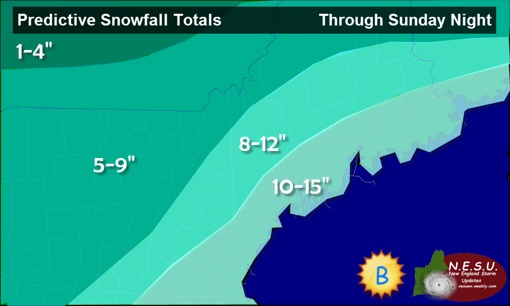
This Storm That's on the horizon Will be a nasty one here are the snowfall totals
-Bobby Koenig
Winter Storm Warning And Snowfall Totals All Will inpact The Christmas Shopping This Weekend12/13/2013 This Storm That's on the horizon Will be a nasty one here are the snowfall totals
-Bobby Koenig
Our storm we have been looking at for a week or so is now kicking into gear over the southeastern US. Rain is spreading northward covering most of the Mid Atlantic states and moving into NYC right now. This morning's precipitation was unrelated associated with a weak warm front that dropped about an inch or so of snow. That is now long gone and temps today will rise to near 40 at the coast and 30 inland.
Precipitation should arrive just after sundown tonight becoming heavy at times. Winds and rain will both pick up in intensity by morning with the worst conditions arriving mid-morning. Rain and wind will continue through the afternoon with the rain diminishing in intensity while the wind holds steady at about 40-50 mph. Wind and rain will diminish in intensity and coverage Wednesday night as the front passes through. We may see a quick shot of snow early Thursday morning but accumulations should be limited to a dusting at best. Winds will become strong out of the NW much like those we saw on Sunday for Thanksgiving day. The mountains should see some up-slope snow showers accumulating 2-4" in favored zones. I expect near 3-3.5" of rain over the area which will cause a rapid rise in streams and rivers despite a relatively dry October-November. Minor flooding could become an issue with very heavy rain rates Wednesday morning. Winds will gust near 50 mph over coastal areas with 40 mph winds inland. With the ground saturated from the heavy rains, power outages will become an issue. Winds will increase out of the SE tonight ahead of the storm and steadily strengthen. Winds will peak between 9 am and 1 pm and subside after that. Winds will again become gusty on Thanksgiving but out of the NW ushering in cooler air. If anything drastically changes, I will have another update tonight but otherwise, I'll have another update on Wednesday morning. -Jack With the storm only 2 days out now, we have a much clearer picture of what will play out over the Eastern Seaboard on the busiest travel day of the year. It looks like the coast will be all rain while inland areas will start with snow then switch over to rain as the day goes on. Even the highest elevations will see rain at some point Wednesday with temps reaching into the 50's on the coastal plain and 40's inland. 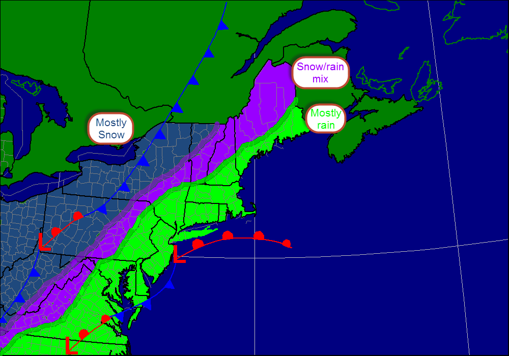
This is my thinking as to the type of precipitation. I expect the only spot in New England to see accumulations will be NW Vermont. The big cities and the I-95 corridor will see a windswept rain shown in green while freezing rain and sleet could cause problems in the purple shaded area. Accumulating snow, shown in blue will be confined to areas like State College PA and Buffalo NY.
Rain Rain will be the main story with this storm as the westerly track will put most on the warm side of the low. Accumulations of 2-5" will be possible region wide with the bulls eye being over central CT. Minor street flooding could become an issue especially in CT where the heaviest rain will be focused. Rain will begin late Tuesday night over southern areas spreading northward through Tuesday night. Rain will become heavy at times Wednesday as the low intensifies. If you're travelling Wednesday, expect slow going on interstates 95, 93, and 89 due to wet conditions. Snow Snow will be confined to far NW VT, upstate NY, PA, OH, and the mountains of the Southern Appalachians. Snow amounts could be quite hefty in areas where lake effect off the northwest winds behind the storm could add to totals. Amounts on the order of 3-6" will be most common though lake effect zones could see upwards of 8". Wind Winds will strengthen out of the southwest tomorrow in anticipation of the storm. This will bring in warmer air resulting in the precipitation being mostly rain. On Wednesday, winds will become very strong out of the SW gusting close to 50 or 55 mph by evening. This combined with the saturated ground will likely cause power outage problems. Winds will turn gusty out of the NW on Thanksgiving ushering in bitter temps for those crazy enough to line up outside of stores before black Friday. I'll have another update tonight if the forecast drastically changes, otherwise I'll be back tomorrow. -Jack As the storm slated to hit Midweek approaches, models are beginning to agree that a complex storm system will move up the coast bringing heavy precipitation. However, where agreement is lacking is in terms of precipitation type. Lets start Wednesday morning when heavy precipitation begins to cause travel problems centered around the I-95 corridor. While low pressure is likely still centered in Georgia, a strong front extending well into Maine will cause heavy precipitation up and down the Eastern Seaboard. Air Travel As the storm winds up over the East Coast, Air travel will be significantly impacted as high winds and heavy precipitation will affect cities like Washington D.C, New York City, Philadelphia, and Boston. Significant delays are expected starting Tuesday night and likely lasting through Wednesday night. Major airports that will be affected are: BOS (Boston), JFK (New York Kennedy), LGA (New York LaGuardia), EWR (Newark), IAD (Washington D.C. Dulles), DCA (Washington National), PHL (Philadelphia) CLT (Charlotte, NC) SAV (Savannah, GA) ATL (Atlanta, GA) Keep in mind that many smaller airports like Portland, ME (PWM), and Hartford, CT (BDL) will also be affected. 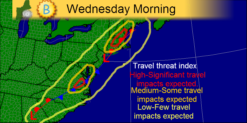
The map above shows where I expect the most significant ravel headaches Wednesday morning. Areas like SE Virginia and Central New England are in the bulls eye for travel delays Wednesday morning. Land Travel For those traveling by Train, Bus, or Car, you will likely experience wet and windy conditions on the I-95 corridor starting Tuesday in the South, and Wednesday as you head farther north. Expect slow going around D.C., New York, and Boston especially later in the day as the storm winds up. 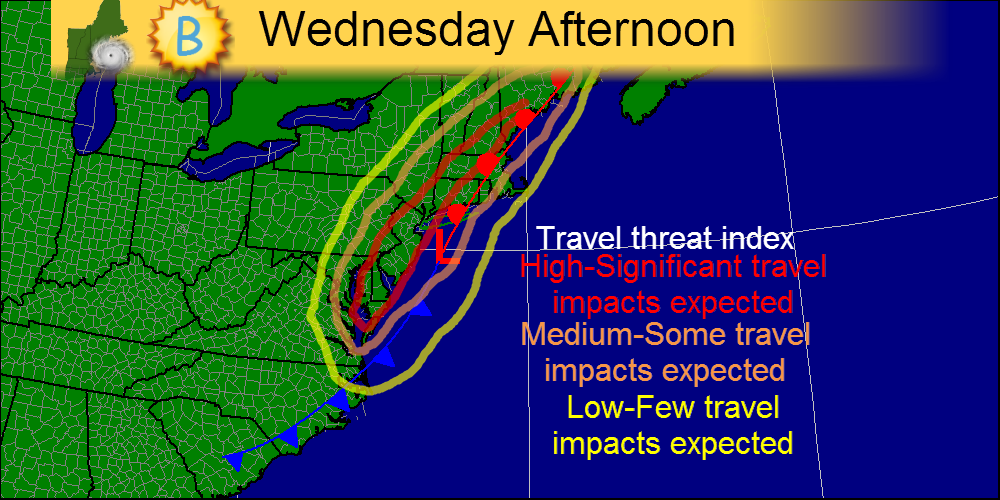
The map above shows where I expect travel to be worst during Wednesday afternoon. Bands of heavy precipitation will be affecting all the major hubs-New York, Boston, and D.C. so significant travel delays are likely.
I will most likely have another quick update tonight. -Jack A powerful cold front will touch off a line of showers and thunderstorms across the region this evening onto tonight. This line is capable of producing damaging winds in excess of 50mph especially over western regions of Maine and New Hampshire. 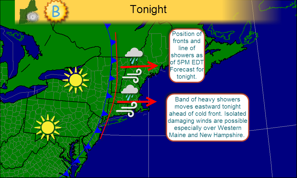
-Jack
Chief forecaster NESU Forecaster, Bweather | AuthorsWe are weather fanatics in Maine, home of some pretty interesting weather. We get hurricanes, nor'easters, floods, severe thunderstorms, heat, cold, and drought and we love to track and talk about it all. ArchivesDecember 2013 CategoriesAll |
 RSS Feed